
Choosing Practical Building Areas on Large Rural Tracts With Drone LiDAR Mapping
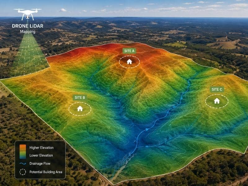
Large rural land brings a challenge that smaller lots do not have. Walking every acre to check possible building spots simply is not practical. Drone LiDAR mapping offers a way around this. It collects height data across a whole tract much faster than a crew walking the same ground.
This does not replace normal ground surveying. But it does give owners and design teams a fast starting point when several spots need to be compared before anyone picks a plan.
Scanning Broad Acreage Without Relying Only on Walked Profiles
A normal ground survey collects data along paths a crew actually walks. That works fine for a small building site, but it takes a lot of time across dozens or hundreds of acres. A drone with a LiDAR sensor covers that same ground from the air, gathering a dense set of height points across the whole property in one flight.
This wider view matters most early in planning, when the goal is understanding the shape of the land, not pinning down exact corners. Seeing the whole property at once, instead of only the parts a crew had time to walk, gives a much fuller picture of what is really possible.
Filtering Vegetation to Model the Underlying Ground
Raw LiDAR data includes hits from everything the laser touches, including tree branches, brush, and other plants above the real ground. Processing this data means sorting out those hits to keep only the ones that show bare earth. This step turns a messy pile of points into a usable land model.
This filtering works better in some spots than others. Areas with lighter tree cover give cleaner ground models. Thick brush under the trees can cut down how many laser hits actually reach the soil.
Separating Ridges, Depressions, and Drainage Routes
Once a clean land model exists, it becomes easy to spot the major shapes across the property without walking a single acre. Ridges, low spots, and natural drainage paths all show up clearly in the data. This gives an owner a sense of how water and land work together across the whole tract.
This kind of overview helps rule out spots early. A candidate site sitting inside a natural drainage path, for example, can be spotted in the data long before a ground crew ever needs to walk that exact spot.
Comparing Candidate Homesites Across the Property
With a full land model ready, several possible building spots can be checked side by side using the same data. Slope, height next to nearby drainage, and general land shape can all be compared across candidate sites without the delay of walking each one on foot first.
This comparison does not replace good judgment. It simply gives the people making the choice a shared, accurate starting point, instead of relying on memory or a quick look from a single visit.
Confirming Selected Locations With Ground Surveying
Once a preferred building spot is picked, normal ground surveying still matters. Aerial mapping gives a great overview, but design work and legal boundaries need the accuracy that comes from field measurements tied to real survey control.
This last step confirms the exact details needed for actual building, including precise heights, boundary ties, and any features that may not have shown up well from the air. Treating the aerial data as a planning tool, not a final answer, keeps the whole process fast and accurate.
Frequently Asked Questions
Can Drone LiDAR see through every tree canopy?
No. Some laser hits can reach the ground even under trees, but thick cover can cut down how much ground the survey actually captures.
Does aerial mapping establish legal property lines?
No. Setting legal boundaries takes the work of a licensed land surveyor, along with proper field proof and research.
Is LiDAR suitable for final foundation layout?
Building layout usually needs exact ground control and field staking, which goes beyond what aerial mapping alone can give.
